Welcome, DKos community, to a continuing series of the most celebrated scenic icons highlighting the Colorado Plateau (a/k/a the Four Corners region of the Southwest). Each diary presents straightforward information from the essentials to more in depth details in the guise of a handy guidebook. Feel free to read as much or as little as you want and it’s okay to skip some of the material. The point is to learn or a lot or a little (your call) and have an enjoyable time on the virtual tour. I also hope it’s the next best thing to being there. By the way, one Dkos community commentator referred to these diaries as "armchair vacations." I like that term and I think he or she hit the proverbial nail on the head.
Kindly note: Previous virtual tours in this series were yesterday's posting of a Geology 101 lighthearted course, Glen Canyon, Monument Valley, Bryce Canyon, the Colorado Plateau, Chaco Canyon, and ethnobotany. These posted URL’s and dates can be accessed through my profile. All the information for the tour series is also extrapolated from a larger two-book tome I hope to publish sometime next year, entitled Famous Landmarks Of The Southwest. This two-book opus lists well over one hundred scenic destinations covering national parks, national monuments, some state parks, tribal lands (like Monument Valley), and archeological ruins. The operative word in the special collection series for the Daily Kos community is extrapolated. This means an abridged account that will cut down on the more lengthy version contained in the ‘Famous Landmarks’ texts.
So, are you ready for another armchair vacation, this time venturing to the deepest cut chasm in the Southwest? Making this boast should not surprise some of you given how the Grand Canyon is supposedly the deepest canyon in North America. I’ll have more to say about this claim later in the diary, though I promise you it is not an exaggeration––Zion's 2,000-foot slice into the terrain really is the deepest cut canyon in one significant way.
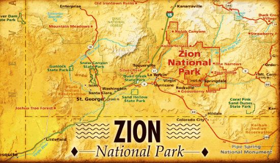
Location/Geography: In southwestern Utah, Washington and Kane Counties. The closest city is Springdale. Zion, the region, covers 146,598 acres (229 square miles). In 2009, Zion added an additional 124,406 acres which was designated Zion Wilderness. The prominent feature of its 229 square miles nterritory is Zion Canyon, 15 miles long and in places half a mile deep. Entry into the park is either from Springdale, in the southern tier or from the Zion-Mt. Carmel in east (headed toward Bryce Canyon or Kanab, Utah).

Continues after the fold, folks. . .
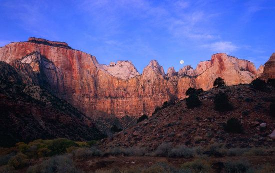
Spotlight (just the facts, ma’am): Zion is the deepest cut canyon created by one principle rock formation (Navajo Sandstone, and now you know the reason behind the above mentioned boast). A multi-province locale creating multitudinous life forms. Two principle entrances (from the east and south). Unlike visiting the Grand Canyon, here visitors see the canyon from the bottom up to the high summit (that is, for those who enter from the south).

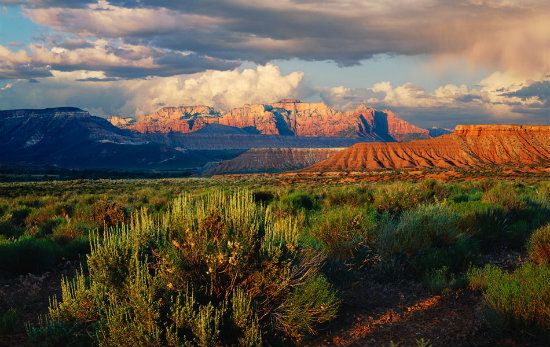
Snapshot (a brief overview): Navajo Sandstone walls jut straight up from the valley floor. Elevation changes from 3,666 feet to 8,726 feet. Zion NP typifies both a sheer chasm profile and a broad, verdant valley. The setting is located on the Markagunt Plateau (Southern Paiute word meaning highland of trees) and the Kolob Plateau. Here, the intersection of three geographic provinces converge: the Great Basin, the Mojave Desert and the Colorado Plateau Province. The northern sector of the park, known as Kolob Canyons, is accessible only from I-15 due north of Las Vegas (or Lost Wages if you prefer). Kolob Terrace is also part of Zion but is a less traveled sector that heads north from the town of Virgin, Utah. The Terrace is also home to one of the most popular hikes in Zion country: the Left Fork of North Creek, commonly known as the Subway. Zion's picturesque geography and variety of life-zones offers unusual plant and animal diversity from all three provinces.
Guided Tour Essentials: Originally, the majestical setting was called Mukuntuweap (pronounced mu-loon-tu-weap) and Straight Cañon. “Weap” is Southern Paiute for canyon and means a deep and narrow gorge. In this case, it's an impressive chasm created by a seemingly benign body of water. Mukuntuweap can also mean straight arrow, canyon, river, and perhaps the land of the springs. The name was later changed to Zion when it was designated a national monument in 1909, which changed status to a national park in 1917. Congress added more land in 1919. A separate Zion NM and the Kolob Canyons annex were proclaimed in 1937. In 1956, the territories were combined into one park.
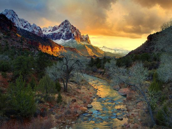
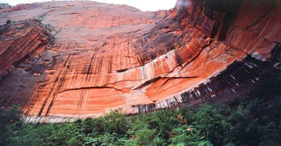
Geology: As previously mentioned, Zion is the deepest cut canyon in the Southwest regarding its principle lithology, Navajo Sandstone. (Lithology means the study of rocks with particular emphasis on description and classification.) The gash through Zion's tan and reddish-to-chalk-colored sandstone was cut by the North Fork of the Virgin River.
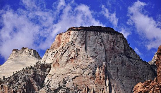
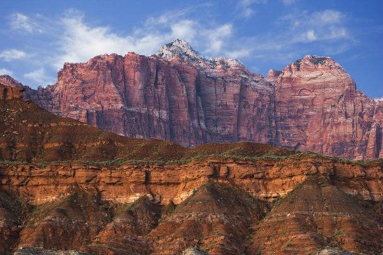
The chasm is entirely Navajo Sandstone, which is a prominent geologic formation in the Glen Canyon Group. Its prominent steep cliff profile ranges from 1,600 to 2,200 feet thick, the red lower layers colored by iron oxides. The highest exposure in the park is West Temple. Cross-bedding is a typical characteristic of wind-blown sandstone. The best example is seen at Checkerboard Mesa, a prominent landmark in the eastern sector.

Think of sandstone as petrified sand dunes. Here at Zion, the dunes covered some 150,000 square miles. Shifting winds during deposition created the cross-bedding effect. Additionally, Navajo Sandstone typically forms above the Kayenta Formation and Wingate Sandstone, which together result in the towering vertical cliffs up to 2,200 feet.
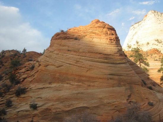
The age of the Navajo Sandstone layer may originate from the Late Triassic (roughly, 228 to 199.5 million years ago) to the Early Jurassic (roughly, 199 to 176 million years ago). The remarkable aspect of the ubiquitous Colorado Plateau Mesozoic Era rock (roughly, 251 to 66 million years ago) is its cross-bedding and distinctive rounded weathering profile. Often, the sandstone colors range from a chalk to a sort of light pink. With its precipitous canyon walls overlooking the slender valley, Zion's interior is adorned with buttes, mesas and giant monoliths that add to the picture perfect tableau. Slot canyons and natural arches are also found here.
A generous view of the immensely thick and sheer Navajo Sandstone:
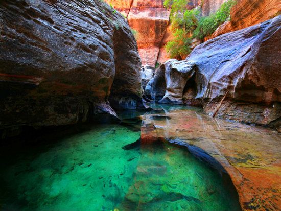
(FYI: A slot canyon is a narrow chasm formed by ordinary and relentless wear of water rushing through rock. These prized hiking canyons are also significantly deeper than wide. Some slots can measure less than three feet across at the top but drop more than one hundred feet to the floor of the canyon. Most slot canyons are also formed in sandstone and limestone, although slot canyons in other rock types such as granite and basalt are possible.)
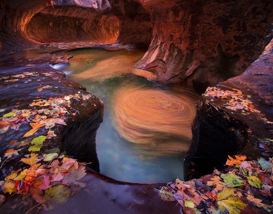
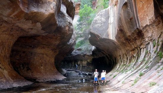
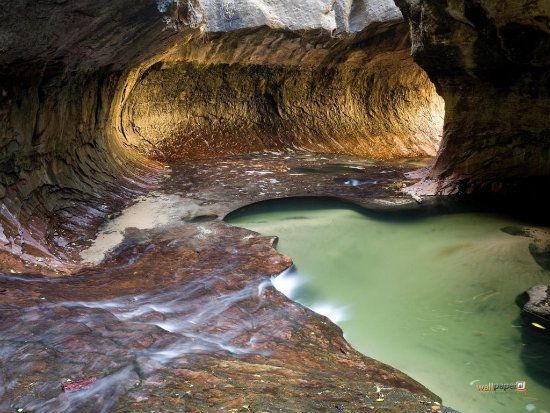
Leading into a slot sector called The Subway:
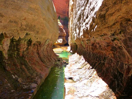
From inside this aptly named fissure:

Another sample of this peerless hiking sector (strenuous, but well-worth the effort):
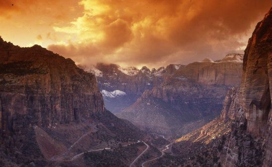
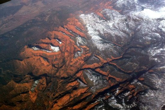
Zion and its adjacent province to the west, Kolob Canyons, include nine major formations representing about one hundred fifty-one million years of Mesozoic sedimentation. Shallow seas, streams, ponds and lakes, deserts, and dry near-shore environments once covered the region. Like the rest of the Four Corners celebrated landmarks, these depositions were laid down one at a time. Once stacked up and compressed, the region awaited a vast uplift (i.e., the geophysical force that created the entirety of the Colorado Plateau), followed by a downcutting from rivers and streams. Here's what the terrain looks like from a raven's perspective. On second thought, let's make it a commercial airliner or a hang glider who's really pushing the envelope:
Eventually, the virgin and mundane appearing landscape was breached and elements of erosion started to fashion the sedimentary materials.
The Kolob Canyons sector:
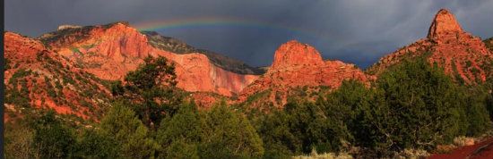
Kolon arch:
Another view of Kolob Canyon's lovely facade:

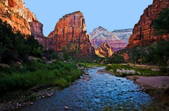
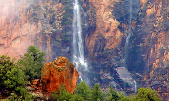
In this region, sandstone was downcut by the Virgin River, creating the canyon and valley floor. High water volume in wet seasons does most of the downcutting. These spectacular flood events are responsible for transporting most of the 3 million tons (2.7 million metric tons) of rock and sediment that the Virgin River annually transports. The river also cuts away the canyon faster than its tributaries. Thus some of the tributaries end in splendorous waterfalls from hanging valleys where they meet the master architect, the main river channel, responsible for creating the canyon's deep gorge. The valley between the peaks of the Twin Brothers is a notable example of a so-called hanging valley. The impressive Three Patriarchs in Zion Canyon are entirely made of Navajo Sandstone, the predominant lithology in the park.
The nine known exposed geologic formations found here are part of a super-sequence of rock units called the Grand Staircase of mostly Mesozoic-era sedimentation. These formations exposed in Zion were deposited as sediments (clastic particles) from different environments. For instance, warm, shallow seas; streams, ponds and lakes; a vast desert; and dry near-shore environments. The adjacent Kolob Canyons setting additionally consist of a set of finger canyons exquisitely cut into the Kolob Plateau.

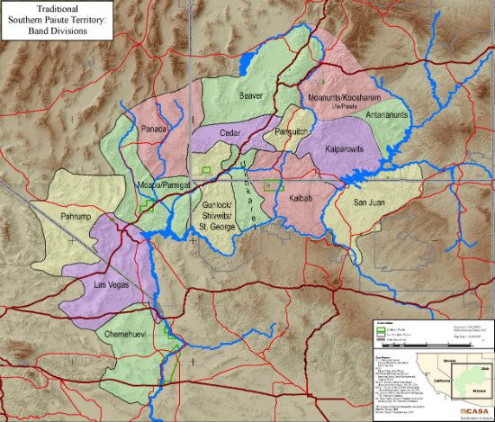
Human History: Archaeologists have divided the long span of Zion's human history into three cultural periods: the Archaic, Protohistoric and Historic. Each is characterized by distinctive technological and social adaptations. Occupation of the Zion region began during the Archaic Period, about 8,000 years ago, of the semi-nomadic Basketmakers that eventually settled in permanent communities. Later during the Protohistoric Period, Parowan Fremont People also lived here. These ancient cultures maintained their respective ways of life, and like the rest of the Colorado Plateau country, most of them vacated the region around 1300. Sometime after an extensive cycle, or at least repetitive cycles, of drought, they migrated elsewhere. The drought caused a depletion of natural resources, including game and the fruits of agriculture. Other Native American tribal people joined the migration, notably the Parrusits and Southern Paiute sub-tribes, all in different waves and at different times. No one knows exactly when they wandered into the Plateau territory, but it's suspected the entirety of the drier-than-usual Southwest was abandoned for at least one hundred years in the 13th Century and possibly later. Thus new settlement began sometime during the following century.
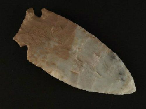
Many sub-tribes, indeed!
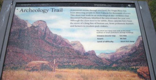
And how'd you like to find something this on the trail? (If so, make sure it gets back to the NPS or some authorized museum for displaying such priceless artifacts):
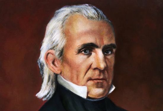
The Historic Period began many centuries later, sometime in the late-18th Century, marking the exploration of southern Utah by Padres Silvestre Vélez de Escalante and Francisco Atanasio Domínguez. The arrival of future new settlement was forthcoming. In 1825, the famed trapper and trader Jedediah Smith explored some of Zion's downstream frontier. Later in 1847, Mormon farmers from the Salt Lake region became the first settlers to settle the Virgin River territory to the south. By1851, the Parowan and Cedar City regions were also settled by Mormons. They were also the people who named the area Kolob, meaning the heavenly place nearest the residence of God. After the Hispanics (Mexicans and the interloping Spaniards who occupied parts of the Southwest, starting in 1540), the Mormons claim the first Anglo settlement as a community of people in what was to become the State of Utah. Meanwhile, politicians in Washington, especially President Polk (1845-1849), showed interest in claiming as much of the Western territory as possible, including California which was already claimed by Mexico. In time, the U. S. Government got what it wanted––the entirety of this ranging territory, which was then protected by Federal law and aggressively defended by the Army of the West under the command of Stephen Watts Kearney. This ambitious effort was due mainly to Polk's venturesome gamble in taking the land from Mexico and the New Mexicans who, for a time, were under the protection of Spain.
Did you mean my Army of the West, my pretty?

Not hardly, my ugly. . .I'm referring to Col. Kearny and his soldiers, whose battalion was ordered by this man (President Polk) to go west and usurp the territory (well, that's what the government's presence in the West was really all about):
Exploration And Settlement by Euro-Americans: After his second historic Green and Colorado River expeditions in 1872, John Wesley Powell visited the Zion region that year. It was also this intrepid and self-made explorer who named the setting Mukuntuweap, with the understanding that the designate was originally of the Southern Paiute.

Major Powell: "What do you people call the name of this place?
Paiute Indian: "Mukuntuweap, white eye with much of right arm missing."
Major Powell: "How do you spell that?"
Paiute Indian: "T-H-A-T. What do you think?
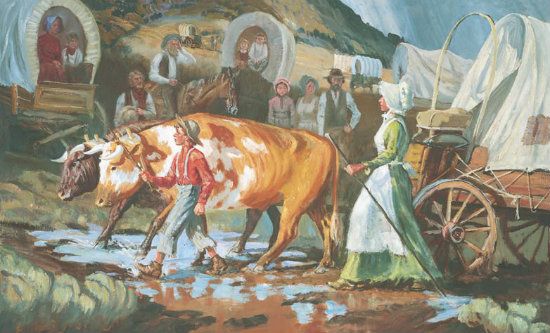
Eventually, Mormons settled here and mostly farmed and grazed cattle while strengthening their vast network of satellite communities. They also decided Zion was a better name for the picturesque canyon––a Hebrew term most often referring to Jerusalem and the Biblical land of Israel. Actually, Zion commonly refers to a specific mountain near Jerusalem (Mount Zion). However, because of the Mormon influence it's thought the name change from Mukuntuweap makes Zion a specific location to which Mormons would gather.
And gather, they did. Here's a rather famous historic painting of these, the first major wave of emigrants into the Western territory (but second to the American Indian tribal people who have lived in this part of the country for at least 13,000 years):
Notable Facts And Places Of Interest: From the highest summit, Horse Ranch (8,726 feet), to the lowest point, Coal Pits Wash (3,666 feet), the difference of elevation creates a stunning relief of some 5,100 feet––straight up!
The stream gradient of the seeming innocuous Virgin River, at its North Fork as it flows through the canyon, ranges from 50 to 80 feet per mile. Normally, the stream flows like an idol; calm and shallow and clear. But when the flash floods hit: talk about a Jekyll and Hyde change of personality. Of course, you don't want to be in the narrows when the water is running fast and high.
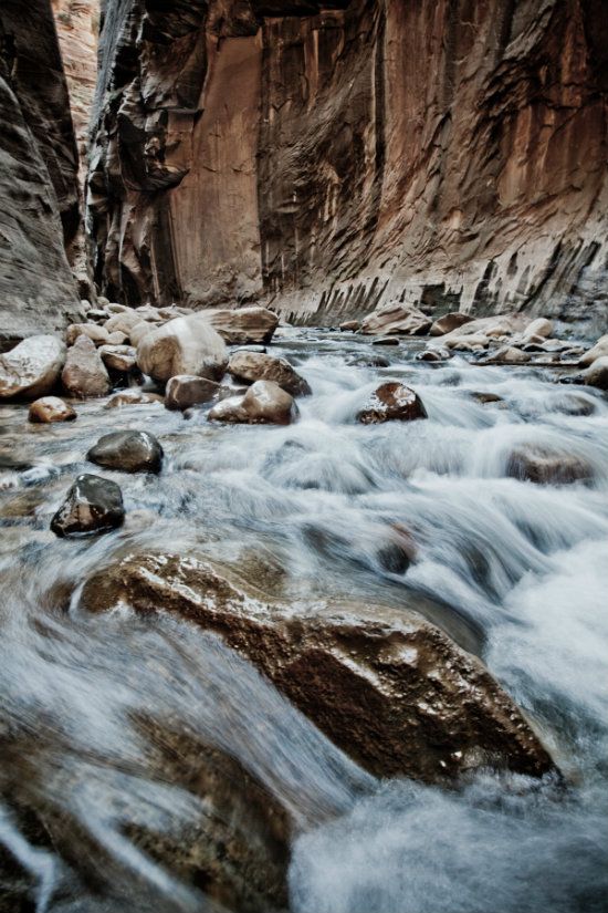
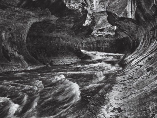
Here's another photo, this one B/W, of the Virgin just starting to get up on her heels, as it were:
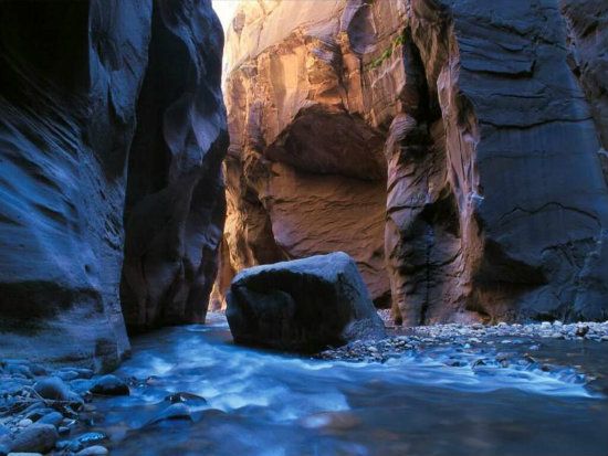
This rate of descent makes it one of the steepest stream gradients in North America. All the streams in the area follow rectangular paths because each follows jointing planes in the rocks that define the geologic setting. The road into Zion Canyon is 6 miles long and ends at the Temple of Sinawava (a Southern Paiute word referring to Coyote God). At the Temple, the canyon considerably narrows to where a foot-trail continues to the mouth of the one of Zion's most popular hiking places, the aptly named Narrows.
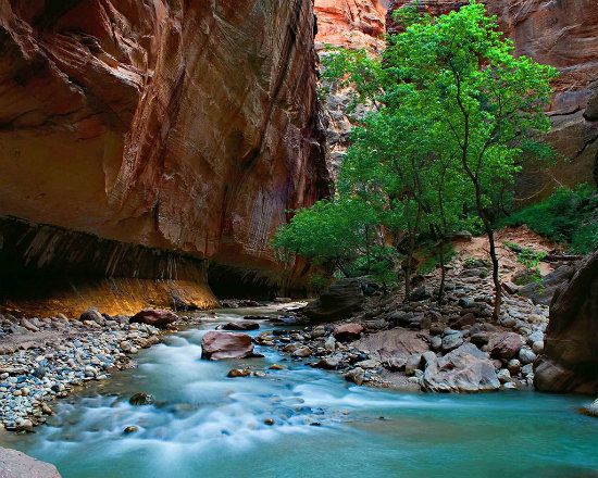
Here is found a deep gorge that, in places, slims down to some 20 feet wide and up to 2,000 feet deep. The east side of the park provides another access route (via the Zion-Mount Carmel highway) that passes through the famed Zion-Mount Carmel Tunnel. The road ends at Mount Carmel Junction where it follows a winding and fairly steep road to the bottom. The start of this eastern sector definitely has a different look and feel to Zion, including a lengthy series of tunnels that changes direction of traffic throughout the day. (Hence, you have to literally know if you're coming or going direction wise.)

Of course, once on the other side of the tunnels you'll be headed for the valley, and of course, winding down to the bottom of canyon. (Of course, trust your brakes and/or downshifting, but no truck "Jake brakes" allowed).
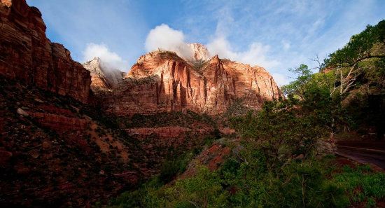
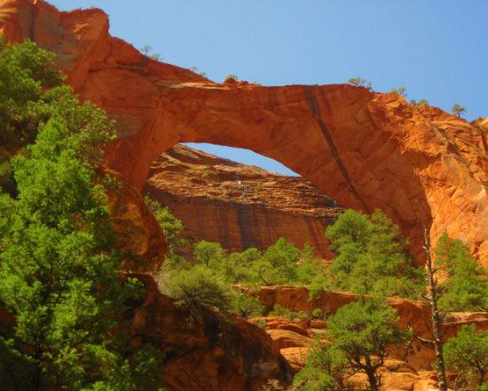
Checkerboard Mesa and the East Temple are the most notable and obvious landmarks coming from this direction. The Kolob Terrace area west of Zion Canyon features the aforementioned Subway, which is a popular and demanding slot canyon hike, also Lava Point, the highest point in the park. Kolob Canyons section, further west and near Cedar City, features Kolob Arch, one of the world's longest arches. Other notable geographical features include: Emerald Pools, Hidden Canyon, Angels Landing, Great White Throne, and Three Patriarchs.
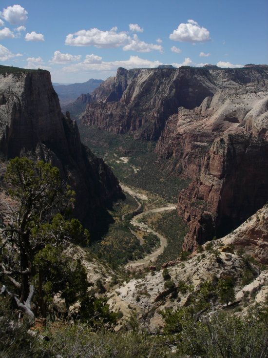
From high atop Angels Landing:

To way down inside The Narrows:
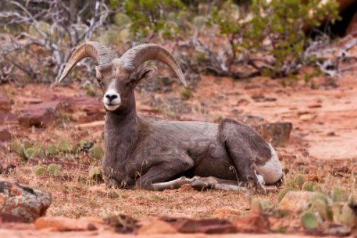
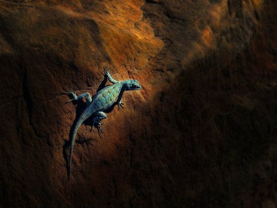
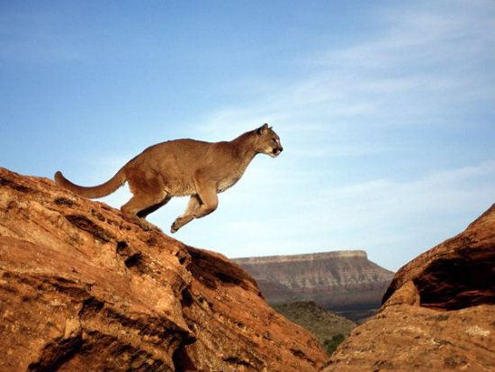
Flora And Fauna: Because of its proximity to the Great Basin and Mojave Desert, numerous plant species abound here. The most notable megafauna include mule deer, golden eagles, pumas (a/k/a cougars or mountain lions) and bighorn sheep. A variety of raptors (i.e., peregrine falcons and red tail hawks), owls and California condors are equally common. Along with the varied topography of the canyon-mesa country throughout this region, the variable soil types and uneven water availability provide diverse habitat for the equally diverse mix of plants and animals that live in the region. These life forms make their homes in one or more of four distinct life zones found inside Zion's boundaries: desert, riparian, woodland and Coniferous forest. Desert conditions persist on canyon bottoms and rocky ledges away from perennial streams.
Some of the more notable wildlife, starting with the Desert Bighorn Ram:
A lovely lizard hanging out in a patch of sunlight:
My favorite big kitty kat, a puma:
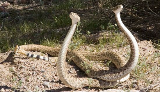
A couple of dancing these guys that onlookers should not bother cutting in:
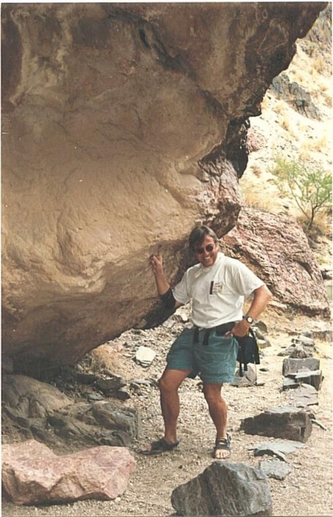
And, of course, the silly tourists acting up in some strange sort of way:
Hiking Trails: Apart from the aforementioned tease of hiking opportunities, there are seven popular trails in the park, each with round-trip times of half an hour (Weeping Rock) to four hours (Angels Landing). Additionally, there are two others, Taylor Creek (four hours round trip) and the very popular Kolob Arch (eight hours round-trip) in the Kolob Canyons section. Hiking up The Narrows from the Temple of Sinawava, which is perhaps the most popular hike, is recommend for summer hiking only, but never during inclement weather (the typical Monsoon season). Orderville Canyon, a narrower slot canyon, is also popular. Backpacking down The Narrows from the top takes about twelve hours. Other often-used back country trails include the West Rim and LaVerkin Creek. Angels Landing is another popular hiking trail, although getting to the top may, for some, pose personal threat (a fear of falling) due to the exposure.
In Zion, you can hike high and dry:

Or low and wet:

And if you're UP for it, try exercising this way:

Note: The final ascent at the summit of the Angels Landing Trail is also a staging point for rock climbing enthusiasts, with short walls like Touchstone, Moonlight Buttress and Spaceshot.
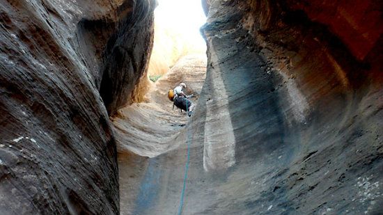
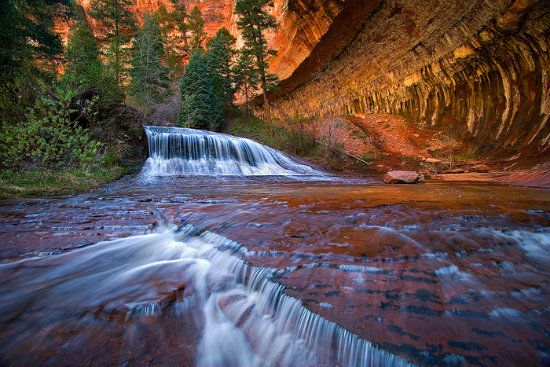
Incidentally, there is an easier way to traverse The Subway and avoid the otherwise cold swimming and rappelling from the upper route. Simply hike the Left Fork of North Creek from the bottom. From the trailhead it's a little over 3 miles each way to get to this popular tunnel, which really does remind one of being inside a subway. The hike, nonetheless, is still strenuous though not technical.
And what a view it'll be along the way:
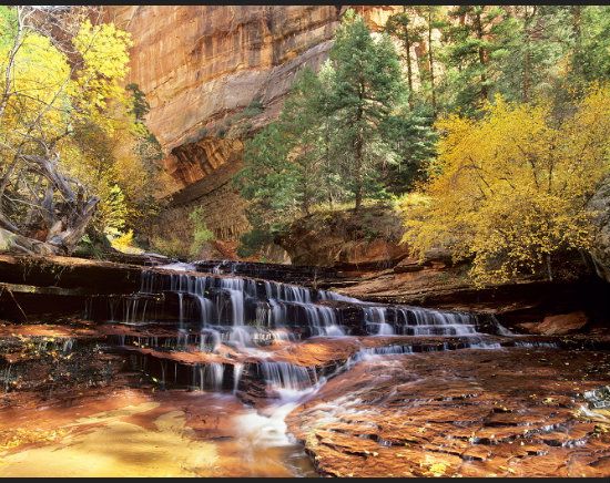
And ending up here, the starting point:
Then some rather tricky hiking in here (sorry, dudes. . .no skateboards allowed):
But if you don't mind getting your feet wet, and sometimes chilled by chest-high water (in places). . .here's the place to hike and slosh (The Narrows):

Directions: I-15 headed north from Las Vegas connects with UT-9 and 17 to the park. Hwy. 89 passes east via the Zion-Mt. Carmel byway and connects with UT-9 (the eastern sector between Kanab and Bryce Canyon). The Visitor Center at the Kolob Canyons entrance is also accessible from I-40 at Exit 40.
Contact Information: Zion National Park, Springdale UT 84767. Phone (park headquarters): 435-772.3256; back country information: 772.0170; Fax 772.3426. Email embedded in NPS site’s URL (click on “Email Us”)
And now you know a lot more about Zion National Park than you did before (an assumption on my behalf). Feel free to share this information with anyone you like. There’ll be more virtual tours to follow in this series. Right now I’m experiencing the usual dilemma of what scenic area to feature, because there are so many on the list to choose. No worries. Next’s week’s posting will likely be a place the DK community will enjoy touring.
As always, intelligent, thoughtful commentary is appreciated.
Rich
http://www.nmstarg.com/...
http://www.grandcanyon.org/...
Thanks for touring with me in Zion. Next week we're going to visit Canyonlands National Park (near Moab, Utah). Join me for another fun and informative adventure! Meanwhile, here's some more delectable scenes from Zion. . .

Finally, and of course, never least. . .