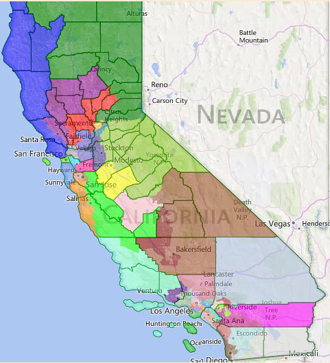
As many of you know, the Supreme Court is set to issue a ruling soon on the legality of independent redistricting commissions in Arizona and California. If the commissions are struck down, then the legislatures of both states will have the opportunity to redraw their congressional districts. While Arizona is controlled by Republicans, and thus likely to produce a Republican gerrymander, California is controlled by Democrats. Thus, the California state legislature could implement a very strong Democratic gerrymander that would both shore up vulnerable Democratic incumbents and give Democrats the opportunity to win several more districts as well.
Here is my proposal for what this Democratic gerrymander should look like. Follow me below the fold to see it.
District 1 (blue): Jared Huffman (D-San Rafael)
Demographics: 77/2/13/4 (white/black/Hispanic/Asian, all VAP)
Prez ’08: 73-25 Obama
Current district’s partisanship: 71-25 Obama ’08, 69-27 Obama ’12 (all these numbers come from here: http://www.dailykos.com/...)
This district, containing the North Coast of California from Marin County to the Oregon border, is very similar to Huffman’s current district. The only differences lie in Sonoma County, where Huffman loses Cloverdale and Healdsburg and gains Rohnert Park. The partisanship difference is miniscule – Huffman is completely safe. SAFE D.
District 2 (green): Doug LaMalfa (R-Richvale)
Demographics: 81/1/10/4
Prez ’08: 57-42 McCain
Current district’s partisanship: 53-42 McCain, 57-40 Romney
This district is the NorCal Republican district, containing Redding, Red Bluff, and Susanville, and then extending south to the outer suburbs of Sacramento, taking in Rocklin and Granite Bay. LaMalfa doesn’t actually live in this district (Richvale is in Butte County, which was moved to the heavily-Democratic 3rd district), but this district is really his only option. This district is even more Republican than LaMalfa’s current district, since it replaces Butte County (which Obama narrowly won in 2008) with part of deep-red Placer County. He’d be completely safe. SAFE R.
District 3 (purple): Mike Thompson (D-St. Helena)
Demographics: 72/1/20/4
Prez ’08: 62-36 Obama
Current district’s partisanship: 70-26 Obama ’08, 70-27 Obama ‘12
This district takes in the remainder of Sonoma County, including Santa Rosa, and then includes part of the Napa Valley, including Thompson’s home in St. Helena, as well as the counties of Lake, Glenn, Colusa, and Butte. Thompson’s district takes a bit of a hit in partisanship, in order to both help Garamendi and create a new Democratic district nearby, but Thompson is very popular and has usually outran the top of the ticket. The district is still heavily Democratic, so Thompson won’t have any trouble. SAFE D.
District 4 (red): John Garamendi (D-Walnut Grove)
Demographics: 56/6/22/12
Prez ’08: 58-41 Obama
Current district’s partisanship: 55-42 Obama ’08, 54-43 Obama ‘12
This district includes Fairfield, most of Napa, and Davis, and then goes north to take in the counties of Sutter and Yuba. Garamendi doesn’t live here (he actually lives in Jerry McNerney’s 17th district), however this district has significant overlap with his current district, which also includes Fairfield, Davis, and Yuba City. This district is also 3 points more Democratic than Garamendi’s current district, which is a welcome improvement considering his relatively narrow 5-point win in 2014. With this improvement, he’d be safe. SAFE D.
District 5 (gold): Doris Matsui (D-Sacramento)
Demographics: 62/8/18/9
Prez ’08: 59-40 Obama
Current district’s partisanship: 68-29 Obama ’08, 69-28 Obama ‘12
This district contains the majority of Sacramento as well as many of its suburbs. In order to protect Ami Bera in the neighboring 6th district, this district sheds many heavily-Democratic areas in south Sacramento to his district, while taking in suburbs such as left-leaning Arden-Arcade, politically-balanced Carmichael, and right-leaning Citrus Heights. Matsui, an uncontroversial incumbent, will still do perfectly fine here. SAFE D.
District 6 (teal): Ami Bera (D-Elk Grove)
Demographics: 45/11/19/21
Prez ’08: 59-40 Obama
Current district’s partisanship: 51-46 Obama ’08, 51-47 Obama ‘12
This district contains south Sacramento, Elk Grove, Rancho Cordova, Fair Oaks, and Folsom. After narrowly defeating an incumbent in 2012 and then hanging on by less than a percentage point in 2014, Bera needs to be made more secure, and this district will do that. Bera loses many of the Republican areas of his district, including Citrus Heights to the 5th and Rancho Murrieta to the 19th. These areas are replaced by heavily Democratic areas in south Sacramento. Bera will be totally safe here. SAFE D.
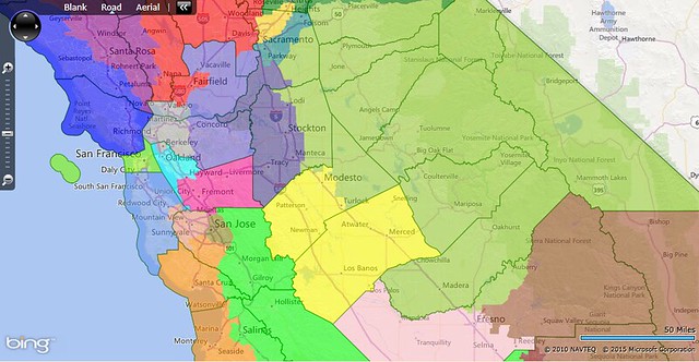
District 7 (dark gray): Open Seat
Demographics: 47/12/18/19
Prez ’08: 79-19 Obama
This is a newly-created district based in the areas of the East Bay north of Oakland. It includes Berkeley, Richmond, Vallejo, Martinez, and Lamorinda. Mark DeSaulnier doesn’t live here (he lives in Concord, which is in the 8th), but much of his current district is here, so he could choose to run here instead of the 8th. If DeSaulnier doesn’t run here, then State Senator Loni Hancock (D-Berkeley) would be a strong candidate for the Dems. But the chances of a Republican winning here are less than zero. SAFE D.
District 8 (slate blue): Mark DeSaulnier (D-Concord)
Demographics: 55/7/22/13
Prez ’08: 62-37 Obama
Current district’s partisanship: 69-28 Obama ’08, 67-30 Obama ‘12
This district is based in eastern Contra Costa County, and contains Concord, Danville, and Antioch. It also extends north into Solano to take in Dixon and part of Vacaville. This district is similar in partisanship to DeSaulnier’s old State Senate district, and considering his easy win last year, he’d be perfectly safe here. If DeSaulnier chooses to run in the 7th instead, then State Assemblywoman Susan Bonilla (D-Concord) would be a strong candidate for the Dems. But a Democrat will win this either way. SAFE D.
District 9 (cyan): Barbara Lee (D-Oakland)
Demographics: 34/19/21/22
Prez ’08: 85-14 Obama
Current district’s partisanship: 87-10 Obama ’08, 88-9 Obama ‘12
This district is very similar to Lee’s current district, except that it drops Berkeley and adds areas south and east of San Leandro. The partisanship changes only slightly. This is still one of the most Democratic districts in both California and the entire country. SAFE D.
District 10 (deep pink): Eric Swalwell (D-Dublin)
Demographics: 36/5/20/36
Prez ’08: 69-30 Obama
Current district’s partisanship: 67-30 Obama ’08, 68-30 Obama ‘12
This district is also very similar to Swalwell’s current district. It just shifts a little bit south, dropping Castro Valley and San Ramon for the rest of Fremont and a small portion of Milpitas. The partisanship is pretty much the same, and Swalwell is still safe. SAFE D.
District 11 (chartreuse): Nancy Pelosi (D-San Francisco)
Demographics: 48/6/12/30
Prez ’08: 86-13 Obama
Current district’s partisanship: 84-13 Obama ’08, 84-13 Obama ‘12
This district is, again, very similar to Pelosi’s current district. It essentially takes in all of San Francisco except the area south of I-280 and west of Route 101. This district is still completely safe for Democrats. SAFE D.
District 12 (cornflower blue): Jackie Speier (D-Hillsborough)
Demographics: 41/3/21/33
Prez ’08: 73-25 Obama
Current district’s partisanship: 73-24 Obama ’08, 74-24 Obama ‘12
This district is quite similar to Speier’s current district, and takes in the remainder of San Francisco and all of San Mateo County except for Menlo Park, East Palo Alto, Atherton, and part of Redwood City. The district’s partisanship doesn’t change – it’s still heavily Democratic and totally safe for Speier. SAFE D.
District 13 (dark salmon): Anna Eshoo (D-Atherton)
Demographics: 44/3/17/33
Prez ’08: 74-25 Obama
Current district’s partisanship: 70-27 Obama ’08, 68-29 Obama ‘12
This district is relatively similar to Eshoo’s current district. It loses its portion of Santa Cruz County and Campbell, and gains Sunnyvale and Santa Clara. Thus, the district becomes even more Democratic, not that Eshoo needed the boost. It’s totally safe for her. SAFE D.
District 14 (olive): Mike Honda (D-San Jose)
Demographics: 23/3/35/37
Prez ’08: 71-28 Obama
Current district’s partisanship: 69-28 Obama ’08, 72-26 Obama ‘12
This district is almost entirely contained within the city of San Jose. It’s plurality-Asian by VAP and heavily Democratic. Honda is made safer by the removal of Cupertino and the addition of some Hispanic areas in central San Jose, which decreases the likelihood that someone like Ro Khanna could defeat him. SAFE D.
District 15 (dark orange): Zoe Lofgren (D-San Jose)
Demographics: 65/2/17/13
Prez ’08: 71-28 Obama
Current district’s partisanship: 68-29 Obama ’08, 71-27 Obama ‘12
This district contains the remainder of San Jose, as well as Campbell and Saratoga, and then goes south to pick up Santa Cruz, Seaside, and Monterey. Both Lofgren and Farr live in this district, however considering that the 16th district doesn’t include any of San Jose, Lofgren would probably run here rather than there. In addition, the 16th contains a majority of Monterey County, which Farr lives in, so Farr would probably run there. This district is heavily Democratic and would be safe for any Democrat who ran here. SAFE D.
District 16 (lime): Sam Farr (D-Carmel), David Valadao (R-Hanford)
Demographics: 35/3/55/5
Prez ’08: 60-39 Obama
Current district’s partisanship: 71-26 Obama ’08, 71-26 Obama ’12 (Farr); 52-46 Obama ’08, 55-44 Obama ’12 (Valadao)
This is one of my favorite districts on the map. One of the questions that I asked myself when drawing this map was what to do with Kings County. Kings County is David Valadao’s political base, and is pretty much the sole reason why CD-21 and SD-14 are both represented by Republicans even though they are both Hispanic-majority districts. The issue here is that Kings County is required by the VRA to be in a majority-Hispanic district, so it can’t be placed in a Republican district, and the Hispanic areas of the Central Valley that are put with Kings County are not Democratic enough and don’t have high enough voter turnout to ensure that their districts are represented by Democrats. So I thought to myself, what areas could I put with Kings County to ensure that the district is represented by a Democrat? My answer is the Salinas Valley and Watsonville. These areas are heavily Hispanic, are more Democratic than the Hispanic areas of the Central Valley, and have higher voter turnout than those areas. Thus, the 16th district is the result. It includes Kings County, Paso Robles, the Salinas Valley, Watsonville, San Benito County, Morgan Hill, and Gilroy. Valadao is the only incumbent who lives here, however he is unknown to 80 percent of the district, and if he ran here, he’d very likely lose. A plurality of this district is in Monterey County, and Sam Farr lives in Monterey County and previously served on the Monterey County Board of Commissioners, so he would probably run and win here. In the case of an open seat, a Hispanic politician such as Assemblyman Luis Alejo (D-Watsonville) would probably win the seat. One final important note: Obama did better in most places here in 2012 than he did in 2008. This district probably voted about 62 percent for Obama in 2012. LIKELY D with Valadao, SAFE D otherwise.
District 17 (dark slate blue): Jerry McNerney (D-Stockton)
Demographics: 40/7/35/15
Prez ’08: 57-41 Obama
Current district’s partisanship: 56-41 Obama ’08, 58-40 Obama ‘12
This district is very similar to McNerney’s current district, and is about a point more Democratic. It loses Antioch, Brentwood, and heavily-Republican eastern San Joaquin County, and gains Tracy and Manteca. McNerney has slightly underperformed his district in the past, but considering that this district voted about 59 percent for Obama in 2012, that shouldn’t matter, and San Joaquin County is trending Democratic anyway. SAFE D.
District 18 (yellow): Jeff Denham (R-Atwater)
Demographics: 45/3/42/7
Prez ’08: 54-45 Obama
Current district’s partisanship: 50-47 Obama ’08, 51-47 Obama ‘12
This district is several points more Democratic than Denham’s current district. It drops its portion of San Joaquin County as well as the more Republican areas of Stanislaus, and adds Merced. Jose Hernandez would likely have narrowly defeated Denham in this district in 2012. This district, however, is essentially drawn for Assemblyman Adam Gray (D-Merced), whose assembly district is entirely contained in this district. Gray has shown an ability to outrun the top of the ticket, which will be useful against a strong incumbent like Denham. LEAN D with Gray, TOSSUP otherwise.
District 19 (yellow-green): Tom McClintock (R-Elk Grove)
Demographics: 71/2/21/3
Prez ’08: 58-41 McCain
Current district’s partisanship: 54-43 McCain, 58-40 Romney
This strongly Republican district stretches from the Sacramento exurbs in El Dorado County down to northern Fresno, taking in the Sierra Nevada foothills in between. McClintock doesn’t live in this district, but then again he doesn’t live in his current district either. Democrats have no chance here. SAFE R.
District 20 (pink): Jim Costa (D-Fresno)
Demographics: 28/6/55/9
Prez ’08: 60-39 Obama
Current district’s partisanship: 57-40 Obama ’08, 59-39 Obama ‘12
This majority-Hispanic district is located entirely in Fresno County, and contains all the heavily-Hispanic cities there. This district is about two points more Democratic than Costa’s current district, which is good considering that Costa has had close races in 2010 and 2014. If Costa chose to retire, a logical successor would be state assemblyman Henry Perea (D-Fresno), whose district is entirely contained in this one. LIKELY D with Costa, SAFE D otherwise.
District 21 (maroon): Devin Nunes (R-Tulare)
Demographics: 23/5/66/4
Prez ’08: 55-44 Obama
Current district’s partisanship: 55-42 McCain, 57-42 Romney
This district is a mashup of Valadao’s and Nunes’ current districts. It loses Fresno and Kings Counties, and thus is entirely in Tulare and Kern. It includes most of Nunes’ hometown of Tulare, but regardless of whether Nunes actually lives here or not, he would most likely run here, since his political base was moved into Kevin McCarthy’s 22nd district. However, considering that Obama won the district by 11 points in 2008, and probably about 15 points in 2012, Nunes would most likely lose. Assemblyman Rudy Salas (D-Bakersfield) would be a strong candidate for the Dems. LIKELY D with Salas, LEAN D otherwise.
District 22 (sienna): Kevin McCarthy (R-Bakersfield)
Demographics: 64/3/25/5
Prez ’08: 65-34 McCain
Current district’s partisanship: 61-36 McCain, 62-36 Romney
This district is a Republican vote sink taking in all the Republican areas in Fresno, Tulare, and Kern Counties, including Clovis, Visalia, and part of Bakersfield. Unlike McCarthy’s current district, it does not extend into Lancaster. This is the most Republican district on this map. SAFE R.
District 23 (aquamarine): Lois Capps (D-Santa Barbara)
Demographics: 62/2/29/5
Prez ’08: 58-41 Obama
Current district’s partisanship: 56-41 Obama ’08, 54-43 Obama ‘12
This district is similar to Capps’ current district; it drops Paso Robles and adds Ojai. This district is two points more Democratic than Capps’ current district, which is good considering that Capps had a close race in 2014. Since this will be an open seat in 2016, I’ll call it LIKELY D, but with a Democratic incumbent, it would probably be safe.
District 24 (indigo): Julia Brownley (D-Westlake Village)
Demographics: 49/2/39/8
Prez ’08: 57-42 Obama
Current district’s partisanship: 56-41 Obama ’08, 54-44 Obama ‘12
This district is very similar to Brownley’s current district. Ojai and parts of Simi Valley and Moorpark are removed, while Castaic and part of Santa Clarita are added. These changes cancel out each other, and the partisanship is unchanged. Considering that Brownley defeated a top-tier opponent during a massive Republican wave by 2 percent, she shouldn’t have too much to worry about here, since the Republicans don’t have anyone else as strong as Jeff Gorell was who could run against her. LIKELY D.
District 25 (pale violet red): Steve Knight (R-Palmdale)
Demographics: 42/12/34/10
Prez ’08: 61-38 Obama
Current district’s partisanship: 49-48 Obama ’08, 48-50 Romney ‘12
This is another of my favorite districts in this map. It is based in the Antelope Valley, and includes Lancaster and Palmdale. When I was drawing it, I was trying to think of a way to ensure that the district voted for a Democrat. Steve Fox proved that Democrats can win the Antelope Valley with the right conditions. But how to make sure that the district always voted for a Democrat? The answer is actually pretty simple: remove Santa Clarita, and add Pasadena. That’s what this district does, and the result is a strongly Democratic district that Steve Knight would definitely not be able to win. A good Democratic candidate would be Assemblyman Chris Holden (D-Pasadena). LIKELY D if Knight runs, SAFE D otherwise.
District 26 (gray): Brad Sherman (D-Sherman Oaks)
Demographics: 55/4/25/13
Prez ’08: 62-37 Obama
Current district’s partisanship: 66-31 Obama ’08, 65-32 Obama ‘12
This district includes most of Santa Clarita as well as much of the San Fernando Valley, including Granada Hills, Porter Ranch, Chatsworth, Northridge, Reseda, Canoga Park, Woodland Hills, Tarzana, and Encino. While this district is a little less Democratic than Sherman’s current district, it’s nothing he can’t handle. SAFE D.
District 27 (spring green): Tony Cárdenas (D-Los Angeles)
Demographics: 20/4/66/9
Prez ’08: 74-24 Obama
Current district’s partisanship: 74-23 Obama ’08, 77-21 Obama ‘12
This district is almost identical to Cárdenas’s current district. He’ll continue to win here without any trouble. SAFE D.
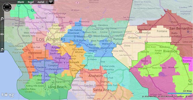
District 28 (plum): Adam Schiff (D-Burbank)
Demographics: 65/3/18/11
Prez ’08: 70-29 Obama
Current district’s partisanship: 70-26 Obama ’08, 70-27 Obama ‘12
This district contains West Hollywood, Valley Village, Burbank, and Glendale. The partisanship is pretty much unchanged from Schiff’s current district. He’s totally safe. SAFE D.
District 29 (dark sea green): Ted Lieu (D-Torrance)
Demographics: 69/3/13/12
Prez ’08: 68-31 Obama
Current district’s partisanship: 64-33 Obama ’08, 61-37 Obama ‘12
This district takes in most of West L.A., including Santa Monica and Beverly Hills, and then extends west to include Simi Valley and part of Moorpark. Lieu doesn’t live anywhere near this district, however this district contains a majority of his current district. Lieu’s hometown of Torrance is split between the South L.A.-based 33rd and the Long Beach-based 34th, and many of the South Bay communities that he currently represents are in the Inglewood-based 32nd. Two possible Democratic candidates for this district are state senator Ben Allen (D-Santa Monica) and Assemblyman Richard Bloom (D-Santa Monica). Unlike Lieu, both Allen and Bloom are Jewish, which should help them considering that this district has a large Jewish population that has been unrepresented ever since Henry Waxman left. Any Democrat who runs here will be able to win easily. SAFE D.
District 30 (light coral): Karen Bass (D-Los Angeles)
Demographics: 17/19/44/18
Prez ’08: 86-13 Obama
Current district’s partisanship: 84-13 Obama ’08, 85-13 Obama ‘12
This district, based in Los Angeles, shifts slightly north and east from Bass’s current district, but is still safe for her. SAFE D.
District 31 (khaki): Xavier Becerra (D-Los Angeles)
Demographics: 12/4/65/17
Prez ’08: 78-20 Obama
Current district’s partisanship: 77-19 Obama ’08, 83-14 Obama ‘12
This district, which includes downtown L.A., Boyle Heights, and East L.A., is heavily Hispanic, heavily Democratic, and completely safe for Becerra. SAFE D.
District 32 (orange-red): Maxine Waters (D-Los Angeles)
Demographics: 28/25/38/6
Prez ’08: 78-20 Obama
Current district’s partisanship: 75-22 Obama ’08, 78-20 Obama ‘12
This district includes much of South Central L.A., including Watts, Westmont, and Inglewood. It also picks up Culver City, Manhattan Beach, and Redondo Beach. This district has the highest percentage of African-Americans of any district on this map. SAFE D.
District 33 (royal blue): Janice Hahn (D-San Pedro), open in 2016
Demographics: 13/23/45/17
Prez ’08: 77-22 Obama
Current district’s partisanship: 81-16 Obama ’08, 85-14 Obama ‘12
This district takes in a wide swath of South L.A., including Hawthorne, Gardena, Compton, and part of Carson. This district has significant overlap with Hahn’s current district, even though she doesn’t live here (San Pedro is in the 34th). Hahn is leaving Congress in 2016, and state senator Isadore Hall III (D-Compton) has already announced that he is running for the seat. Hall, or any other Democrat, would win this district easily. SAFE D.
District 34 (lime green): Alan Lowenthal (D-Long Beach)
Demographics: 41/8/32/16
Prez ’08: 62-36 Obama
Current district’s partisanship: 58-39 Obama ’08, 60-38 Obama ‘12
This district takes in most of Long Beach, San Pedro, Wilmington, Palos Verdes, and half of Torrance. While Janice Hahn lives here, she is leaving Congress in 2016, and her likely successor lives in the 33rd, so Lowenthal should have an easy path here. SAFE D.
District 35 (dark orchid): Lucille Roybal-Allard (D-Los Angeles)
Demographics: 8/7/80/4
Prez ’08: 77-22 Obama
Current district’s partisanship: 77-19 Obama ’08, 82-17 Obama ‘12
This district, the most heavily Hispanic district on this map, contains part of L.A. as well as Florence, South Gate, Downey, and Bellflower. Roybal-Allard isn’t in any danger here. SAFE D.
District 36 (orange): Linda Sánchez (D-Lakewood)
Demographics: 19/3/64/13
Prez ’08: 66-33 Obama
Current district’s partisanship: 61-35 Obama ’08, 65-33 Obama ‘12
This district is quite similar to Sánchez’s current district, and contains Montebello, Pico Rivera, Whittier, and Norwalk in addition to her hometown of Lakewood. It’s heavily Hispanic and strongly Democratic, and Sánchez is totally safe here. SAFE D.
District 37 (dodger blue): Judy Chu (D-Monterey Park)
Demographics: 13/1/36/48
Prez ’08: 62-37 Obama
Current district’s partisanship: 61-35 Obama ’08, 63-35 Obama ‘12
This district has the highest percentage of Asians of any district on this map. The district includes Monterey Park, San Gabriel, Arcadia, Rosemead, El Monte, Hacienda Heights, and Diamond Bar. The district has a mix of more working-class and more middle-class communities, but is solidly Democratic anyway, and Chu has nothing to worry about. SAFE D.
District 38 (medium aquamarine): Grace Napolitano (D-Norwalk)
Demographics: 27/4/54/14
Prez ’08: 62-37 Obama
Current district’s partisanship: 62-35 Obama ’08, 65-33 Obama ‘12
This district includes most of the eastern San Gabriel Valley, including Baldwin Park, West Covina, and Pomona. Napolitano doesn’t live in this district, however she doesn’t live in her current district either. The conservative cities like Glendora are easily outvoted by the heavily Hispanic and Democratic areas. SAFE D.
District 39 (moccasin): Norma Torres (D-Pomona)
Demographics: 25/7/56/10
Prez ’08: 59-39 Obama
Current district’s partisanship: 64-32 Obama ’08, 67-31 Obama ‘12
This district is one of three that are based in San Bernardino County, and one of the two Democratic ones. It contains Fontana, Ontario, and Chino. While Torres doesn’t live in this district (she lives just over the L.A. county line in Pomona, in the 38th), this district has over 80 percent overlap with her old state senate district, and she would definitely run here. Considering that Democrats have recently won low-turnout special elections in this area, Torres probably won’t have much trouble winning re-election here. SAFE D.
District 40 (firebrick): Pete Aguilar (D-Redlands)
Demographics: 31/12/47/8
Prez ’08: 59-39 Obama
Current district’s partisanship: 56-41 Obama ’08, 57-41 Obama ‘12
This district takes in the eastern part of the San Bernardino Valley, and includes San Bernardino, Colton, and most of Rancho Cucamonga, Rialto, and Redlands. It is almost identical in partisanship to the neighboring 39th district, and very similar to Aguilar’s current district. Now that Aguilar is an incumbent, and considering that this district is a few points bluer than his current district, Aguilar will be fine here. SAFE D.
District 41 (light steel blue): Paul Cook (R-Yucca Valley)
Demographics: 58/7/29/4
Prez ’08: 58-41 McCain
Current district’s partisanship: 55-42 McCain, 56-42 Romney
This district includes the conservative remainder of San Bernardino County, including the Victorville area, Yucaipa, Yucca Valley, and Barstow. It’s not dramatically different from Cook’s current district, except that it no longer contains Mono and Inyo Counties. Cook is totally safe here. SAFE R.
District 42 (lawn green): Mark Takano (D-Riverside)
Demographics: 33/7/49/9
Prez ’08: 57-41 Obama
Current district’s partisanship: 59-38 Obama ’08, 62-36 Obama ‘12
This district is one of the three that are based in Riverside County, and it includes most of the city of Riverside as well as Eastvale, Jurupa Valley, most of Corona, and Perris. It’s about two points to the right of Takano’s current district, however that’s not a big deal since neither of Takano’s two elections have been particularly close. This area has been trending Democratic, so Takano shouldn’t have much trouble. SAFE D.
District 43 (magenta): Raul Ruiz (D-Coachella)
Demographics: 43/6/45/4
Prez ’08: 57-42 Obama
Current district’s partisanship: 50-47 Obama ’08, 51-48 Obama ‘12
This district is relatively similar to Ruiz’s current district, with just a couple important changes. Hemet and Calimesa have been removed from the district, and strongly-Democratic Moreno Valley has been added. This moves the district from a marginal one to a substantially more Democratic one. Considering that Ruiz defeated a top-tier challenger by 8 points in a marginal district during a Republican wave, Ruiz will be pretty secure in this more-Democratic district. SAFE D with Ruiz, LIKELY D if open.
District 44 (medium violet red): Ken Calvert (R-Corona)
Demographics: 59/5/27/7
Prez ’08: 57-42 McCain
Current district’s partisanship: 54-43 McCain, 57-41 Romney
This district takes in all the most Republican areas of Riverside County, from Norco to Menifee to Hemet to Temecula. It fits perfectly into the remaining area of Riverside County, since San Bernardino plus Riverside has just the right population for six districts, three based in each county. Calvert will cruise to re-election here. SAFE R.
District 45 (turquoise): Ed Royce (R-Fullerton)
Demographics: 60/1/21/16
Prez ’08: 57-42 McCain
Current district’s partisanship: 49-47 McCain, 51-47 Romney
We now head over to Orange County, where I try to give the Democrats two winnable districts rather than their current one. However, first we have this heavily Republican district that includes the Republican areas of Anaheim, Orange, and Fullerton, and all of La Habra, Brea, Yorba Linda, Lake Forest, and Mission Viejo. These cities represent classic OC conservatism, and no Democrat would stand a chance here. SAFE R.
District 46 (tomato): Loretta Sanchez (D-Santa Ana)
Demographics: 23/2/56/17
Prez ’08: 59-40 Obama
Current district’s partisanship: 58-39 Obama ’08, 61-36 Obama ‘12
This district is the successor to Loretta Sanchez’s current district. It has been moved a bit north and west, and now includes most of Buena Park and Anaheim, about half of Fullerton, part of Orange, and about half of Santa Ana. This district is still majority-Hispanic, and its partisanship is almost identical to that of Sanchez’s current district. Any Hispanic Democrat, such as Sanchez or Lou Correa, would win this with ease. SAFE D.
District 47 (thistle): Dana Rohrabacher (R-Costa Mesa)
Demographics: 53/1/18/26
Prez ’08: 54-45 McCain
Current district’s partisanship: 51-46 McCain, 55-43 Romney
This district, based in Huntington Beach, also includes Cypress, Fountain Valley, Newport Beach, and the Vietnamese communities in Garden Grove and Westminster. Rohrabacher doesn’t live in this district (Costa Mesa is in the 48th), however he would most likely run here, since 1) much of the area of his current district is here, and 2) the 48th district leans Democratic. This district is safe for any Republican. SAFE R.
District 48 (sandy brown): Mimi Walters (R-Laguna Niguel)
Demographics: 46/2/30/20
Prez ’08: 56-42 Obama
Current district’s partisanship: 51-46 McCain, 55-43 Romney
This district is my attempt to draw a second district in Orange County that is winnable for Democrats. This district contains part of Santa Ana, as well as Tustin, Costa Mesa, Irvine, Laguna Woods, Aliso Viejo, and Laguna Beach. All of these cities voted for Obama in 2008, and most did in 2012 as well. Walters probably doesn’t live in this district, since it contains only a small slice of Laguna Niguel, however she represents much of this area already, and doesn’t have any better options. Democrats don’t have much of a record of winning elections here, and state legislative Republicans generally outperform the top of the ticket, but in a district designed to give Democrats a chance at victory, they’ll probably get more serious about their campaigns. Winning here won’t be easy for the Dems, though. TOSSUP.
District 49 (indian red): Darrell Issa (R-Vista)
Demographics: 65/2/23/7
Prez ’08: 53-46 McCain
Current district’s partisanship: 49-48 Obama ’08, 52-46 Romney
This district includes both coastal and inland areas on both sides of Camp Pendleton. It takes in Laguna Niguel, San Juan Capistrano, and San Clemente in Orange County, and Oceanside, Vista, and Carlsbad in San Diego County. This area is even more Republican downballot than the presidential numbers suggest, and that, coupled with the fact that Issa is a strong incumbent, means that the district is out of reach for Democrats. SAFE R.
District 50 (powder blue): Duncan Hunter (R-Lakeside)
Demographics: 64/2/22/9
Prez ’08: 58-41 McCain
Current district’s partisanship: 58-39 McCain, 60-38 Romney
This district takes in all the remaining Republican areas of San Diego County, including Escondido, Poway, Ramona, Santee, and Lakeside. This is some of the most rock-ribbed and reliably Republican turf in the entire state. Hunter, a popular incumbent, is totally safe here. SAFE R.
District 51 (saddle brown): Scott Peters (D-La Jolla)
Demographics: 65/3/13/16
Prez ’08: 61-38 Obama
Current district’s partisanship: 55-43 Obama ’08, 52-46 Obama ‘12
This district includes Encinitas, Solana Beach, and Coronado, along with the San Diego neighborhoods of Mira Mesa, University City, Point Loma, and Balboa Park. Both of Peters’ elections so far have been close, so this district shores him up significantly, moving six points more Democratic than his previous district. Peters matches his district well and is getting increasingly entrenched, so it would be incredibly difficult for a Republican to beat him in this new district. SAFE D.
District 52 (olive drab): Susan Davis (D-San Diego)
Demographics: 47/10/28/12
Prez ’08: 62-37 Obama
Current district’s partisanship: 61-36 Obama ’08, 61-36 Obama ‘12
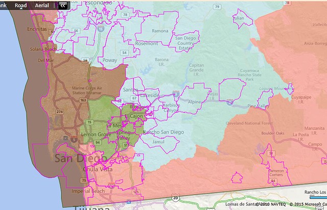
This district takes in east San Diego as well as La Mesa, Lemon Grove, El Cajon, Spring Valley, and La Presa. It has a very similar partisanship to Davis’ current district, so Davis will be fine. SAFE D.
District 53 (gainsboro, salmon in inset map): Juan Vargas (D-San Diego)
Demographics: 20/5/63/10
Prez ’08: 62-37 Obama
Current district’s partisanship: 65-32 Obama ’08, 69-29 Obama ‘12
This district includes Imperial County, Chula Vista, Imperial Beach, and National City, as well as San Ysidro and a heavily-Hispanic neighborhood of San Diego adjacent to National City. The final district on this map is, once again, heavily Democratic, and Vargas won’t break a sweat here. SAFE D.
Thus, the 53 districts described here fall into the following categories:
36 SAFE D (1,3,4,5,6,7,8,9,10,11,12,13,14,15,17,26,27,28,29,30,31,32,33,34,35,36,37,
38,39,40, 42,43,46,51,52,53)
6 LIKELY D (16,20,21,23,24,25)
1 LEAN D (18)
1 TOSSUP (48)
9 SAFE R (2,19,22,41,44,45,47,49,50)
The current map sends 39 Democrats and 14 Republicans to Congress. Of those 14 Republicans, nine are given safe districts, while two (Denham and Walters) are put in more swingy districts (districts 18 and 48, respectively) and three (Valadao, Nunes, and Knight) are put in much more Democratic districts (districts 16, 21, and 25, respectively). In addition, many of the Democrats who have faced close races recently, such as Garamendi, Bera, Aguilar, Ruiz, and Peters, are given safer districts.
This map is the most efficient way to ensure that as many Democrats are elected to Congress from California as possible, while still following the VRA, keeping most districts relatively compact, and keeping cities whole whenever possible. This map protects the Democrats who are currently in safe districts, shores up those who aren't, and creates many new opportunities for Democrats to win even more seats than they have now. If the Supreme Court strikes down California's independent redistricting commission, I urge the California State Legislature to install this map as the new map of California's 53 congressional districts.
The author can be contacted by e-mail (thecliffsofbergama@yahoo.com) or Twitter (@PrdNewEnglander).

